Summary of the ICLC Roadmap to Save Lake Chad
After the conclusion of the International Conference on Lake Chad (ICLC) in Abuja, Nigeria February 26th – 28th, 2018, a Roadmap was issued with the Transaqua Transfer Scheme as the “preferred option” to save Lake Chad. A Bonifica/PowerChina alliance for Transaqua has emerged, supported by two feasibility study grants: $1.8M from PowerChina and $1.8M from the Italian government (Bonifica is an Italian company.) In effect, these pledges have assured that Bonifica’s extremely expensive, multi-decade Transaqua Water Transfer Scheme is the current primary focus for saving Lake Chad.
Importantly, the ICLC Roadmap concluded that Inter-Basin Water Transfer (IBWT) from the Ubangi River (and the Congo River Basin) is no longer an option but a necessity to save Lake Chad. The Roadmap envisioned that IBWT should be a Pan-African project. The Roadmap also recommended that the African Development Bank create a Lake Chad Fund of US $50 billion for IBWT. [NB: the 2018 government budget for Nigeria is $27.34 billion – 8.6 trillion naira. Perhaps the state-owned PowerChina Corporation will finance the construction of Transaqua, as they did the Soubre hydropower dam in Cote d’Ivoire.]
Analysis of the Tranaqua Scheme
Bonifica (Italy) first introduced the Transaqua Project in the early 1980s. It was previously rejected for being too large. From the materials provided by Bonifica, it is difficult to understand the Transaqua Scheme. The following discussion is intended to clarify the details and extent of this ambitious megaproject.
The Transaqua Project would take water from many northern and eastern tributaries of Congo River, conveying water in a 2,400 km canal to the headwaters of the Chari River. The Congo Basin can be conceptualized as a large, shallow bowl, tilted higher in the east and lower in the west, allowing the Congo River to flow westward toward the Atlantic Ocean. The Transaqua canal traverses a line of constant elevation across the hilly topography of the northern and eastern Congo Basin, crossing into the Lake Chad Basin in the Central African Republic, presumably at an elevation higher than Lake Chad (286 m above sea level). [NB: This critical topographic plan for the Transaqua Canal needs to be independently checked using the global Digital Elevation Model from the Shuttle Laser Altimeter (SLA) – a free NASA resource. If there are elevation errors, especially where the canal crosses the inter-basin crest from the Congo Basin into the Lake Chad Basin, the Transaqua Scheme may not work.]
The Bonifica map below shows the Transaqua canal route. Each small red dot signifies a River Port with an associated Agricultural Development Area. Significantly, each River Port also crosses a tributary river to the Congo River (cutting off most of the headwaters of the Congo River). Thus, each tributary along the route must have a dam to prevent water from draining out of the canal. In between the tributaries, higher land must be excavated to form the channel of the canal. The Transaqua Project can be characterized as a series of dams and excavated channels to form a continuous canal at constant altitude.
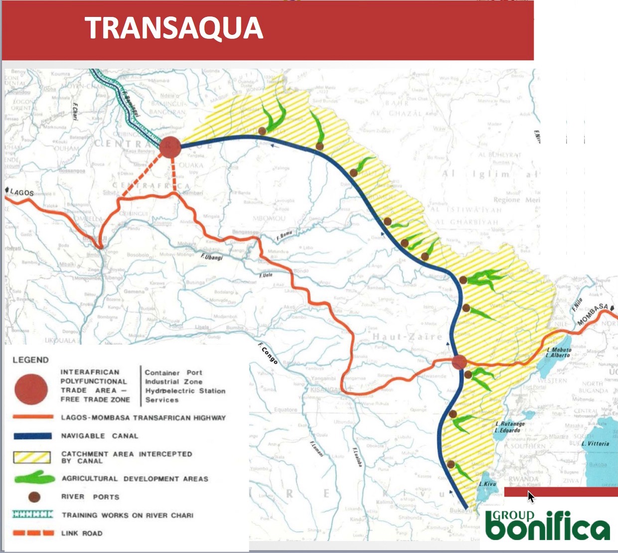
Bonifica claims that Transaqua will transfer 50 billion m3/y to Lake Chad (although some Bonifica documents claim 100 billion m3/y to Lake Chad). Surplus water from the NW terminus of the canal at Bamingui in the Central African Republic can be fed into the Chari River, which then flows into Lake Chad (NB: boat navigation on the Chari is not possible). The Congo River discharges an average of 1300 billion m3/y to the Atlantic Ocean, so Transaqua will take about 3.8% of the water from the Congo River (although some Bonifica documents say 8%).
Bonifica also claims Transaqua will generate 35,000 million kwh/y, which is equivalent to about 4,000 MW of generation capacity, equal to current average power generation in Nigeria. In comparison, the Grand Inga dams on the Lower Congo River have the potential to generate 40,000 MW. Thus, Transaqua hydroelectric power will be about 10% of the Inga dams. It is not clear how this power could be distributed or used in the remote eastern region of the Congo Basin.
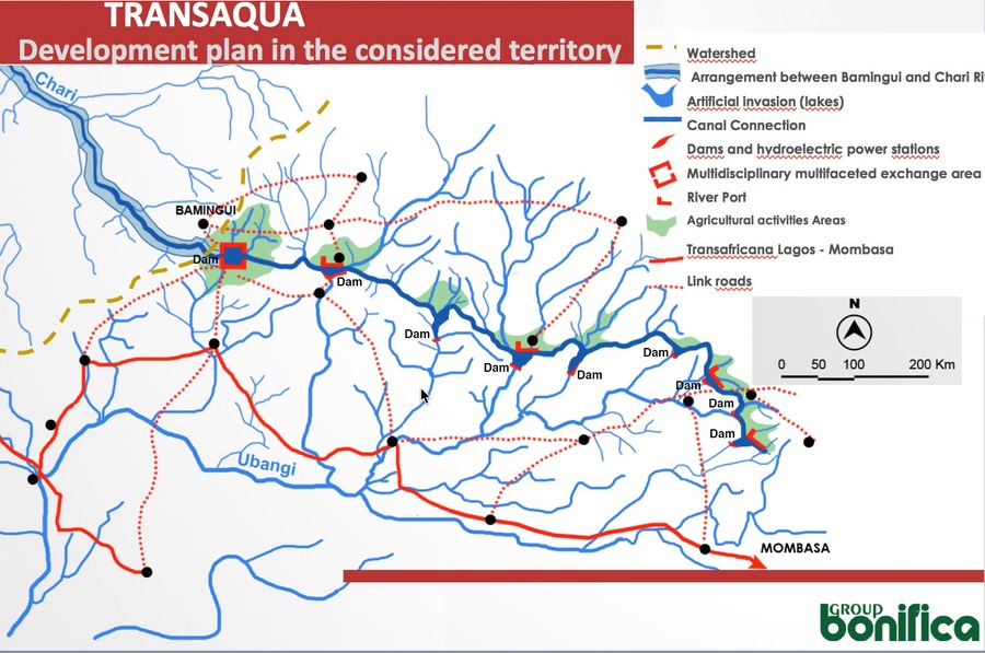
A more detailed view of the northern 1000 km Transaqua canal in the Central African Republic is provided below. Small red hash-marks indicate dams and hydroelectric power stations (each also marked Dam). In this section of the canal, 9 dams are shown, including a dam at the NW terminus of the canal at Bamingui in the CAR (not properly located on the Bonifica map). In total, the Transaqua project will require approximately 20 dams, many of them hydroelectric. Effectively the Transaqua Canal is a gigantic hydroelectric reservoir.
Problems with the Transaqua Scheme
The 2400 km Transaqua canal is almost 9 times longer than the combined lengths of the Suez and Panama Canals. It will be (by far) the largest in the world, able to allow navigation by cargo ships (built on site in the DRC). However, the Transaqua ship canal does not connect with the Congo River, or Lake Chad, or an ocean, so it is landlocked waterway in the remote Congo Basin. Bonifica has not suggested what type of cargo the ships will carry or logical port destinations. In addition, the Transaqua Canal will be a major geographical barrier to endangered wildlife in the region.
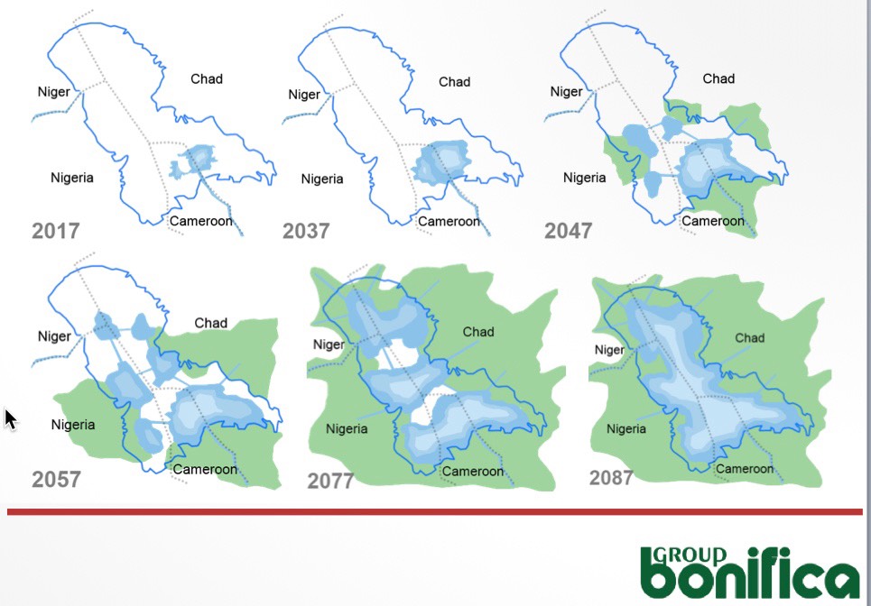
Since the Transaqua Project is so large, it will take multiple decades to complete (many dams must be constructed for water to flow to Lake Chad). It is probable that Lake Chad will go extinct before any significant new water will flow into the lake from the Transaqua scheme. Even if $50-70 billion were forthcoming (a low estimate compared to the cost per kilometer of enlarging the Suez Canal), and even if the DRC did not object to incursion in its territory, Transaqua probably cannot save Lake Chad. The Bonifica maps below predict that it will take 30 years (until 2047) before the lake has a noticeable increase in water. That is much too slow.
[NB: Neither the LCBC, nor Bonifica, nor PowerChina have published a Terms of
Reference for the scope of work for the combined $3.6M Engineering Study of
Transaqua. Without this document, and the results of the study, stakeholders cannot
judge the feasibility, impacts, and true costs of the Transaqua Scheme.]
Solar Option Alternative
As an alternative or a compliment to Transaqua, the LCBC should consider the Solar Option, which could begin replenishing the lake within 5 years, before it is too late. The Solar Option was presented and well-received at the ICLC Conference. The LCBC could do a formal engineering study of the Solar Option in parallel with the planned studies of the Transaqua Scheme, order to have a backup plan if Transaqua should prove infeasible.
Here are four crucial reasons why the Solar Option should be studied:
• The Solar Option can deliver water to Lake Chad in about 5 years (instead of 20 – 30
years for Transaqua).
• The Solar Option does not require constructing dams (quicker delivery of water,
less environmental impact, and a scalable project).
• The Solar Option is about 15% of the cost of Transaqua.
• The Solar Option does not generate transborder conflicts with the DRC.
For a brief overview of the Solar Option, please view the Solar Option Videos. For a summary of the Solar Option, view the selections on the Info & Report page. For sample engineering calculations for the Solar Option, see the ICLC Conference Technical Paper. Finally, a Terms of Reference for the scope of work for an Engineering Study of Solar Option is available. [NB: Des versions en français du document technique et des termes de référence sont disponibles.]